 Ever wanted to know the boundaries of your zip code? Go here and find out. It's a neat little application that combines census data and the Google Maps interface to build you an outline of your zip code.
 I think it is kind of interesting to see how larger cities are divided up into their zip code areas. I was always confused by some of the zip code shenanigans in Rochester and St. Cloud. I had a hard time remember which part of town was supposed to be which zip code, but now I can just get a visual reminder.
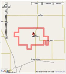
The picture here is an outline of my hometown, Waltham, MN. You see the bump out all the way on the left of the outline? That's the area where I grew up. Kind of interesting to see all of the area my youthful zip code encompassed.
Also, you can switch to the Google Earth view and get a picture of the actual area and overlay the boudaries so that you can see it in a different way (besides the road outlines). I'm constantly amazed by the different applications that people come up with for using Google Earth and Google Maps.
No comments:
Post a Comment